Research projects

Visualization, Data Quality, and Scale in Composite Bathymetric Data Generalization

Contemporary bathymetric data collection techniques are capable of collecting sub-meter resolution data to ensure full seafloor-bottom coverage for safe navigation as well as to support other various scientific uses of the data. Moreover, bathymetry data are becoming increasingly available. Datasets are compiled from these sources and used to update Electronic Navigational Charts (ENCs), the primary medium for visualizing the seafloor for navigation purposes, whose usage is mandatory on Safety Of Life At Sea (SOLAS) regulated vessels. However, these high-resolution data must be generalized for products at scale, an active research area in automated cartography. Algorithms that can provide consistent results while reducing production time and costs are increasingly valuable to organizations operating in time-sensitive environments. This is particularly the case in digital nautical cartography, where updates to bathymetry and locations of dangers to navigation need to be disseminated as quickly as possible. Therefore, this research covers the development of cartographic constraint-based generalization algorithms operating on both Digital Surface Model (DSM) and Digital Cartographic Model (DCM) representations of multi-source composite bathymetric data to produce navigationally-ready datasets for use at scale. 
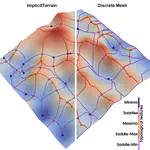
Similarly, many coastal data analysis applications utilize unstructured meshes for representing terrains due to the adaptability, which allows for better conformity to the shoreline and bathymetry. Finer resolution along narrow geometric features, steep gradients, and submerged channels, and coarser resolution in other areas, reduces the size of the mesh while maintaining a comparable accuracy in subsequent processing. Generally, the mesh is constructed a priori for the given domain and elevations are interpolated to the nodes of the mesh from a predefined digital elevation model. Mesh simplification is a technique used in computer graphics to reduce the complexity of a mesh or surface model while preserving features such as shape, topology, and geometry. This technique can be used to mitigate issues related to processing performance by reducing the number of elements composing the mesh, thus increasing efficiency. The primary challenge is finding a balance between the level of generalization, preservation of specific characteristics relevant to the intended use of the mesh, and computational efficiency. Despite the potential usefulness of mesh simplification for reducing mesh size and complexity while retaining morphological details, there has been little investigation regarding the application of these techniques specifically to Bathymetric Surface Models (BSMs), where additional information such as vertical uncertainty can help guide the process. Toward this effort, this research also explores the effects of BSM mesh simplification on a coastal ocean model forced by tides in New York Harbor.

Distributed topology-based terrain analysis using Apache Spark

High-quality and extensive LiDAR data support and enhance large-scale terrain modeling. Triangulated Irregular Networks (TINs) are widely used representations for modeling a terrain topology, even on irregularly sampled raw data. One major application of TINs is for the efficient extraction of morphological features. Morphological features are defined by critical points on the terrain (such as peaks, valleys, and ridges) and their connectivity, which are fundamental for terrain analysis in many applications, including urban analysis, forest monitoring, and bathymetric simulations. However, existing data structures for TINs experience a prohibitive memory cost when computing the connectivity of the terrain and when extracting its morphological features, especially on large datasets comprising billions of points. We address this problem by proposing a novel framework for efficient and scalable topological analysis of large TINs using Apache Spark. The proposed framework, called Morse- Spark, is based on a novel data structure for encoding a TIN on distributed frameworks and integrates distributed algorithms inspired by Discrete Morse theory to extract connectivity relations, critical points, and their regions of influence. To prove the effectiveness and scalability of such a framework, we compare Morse-Spark against three well-established software libraries for topology-based TIN analysis. Our experimental evaluation with real-world TINs shows that Morse-Spark can effectively handle datasets at least 20 times bigger than any other approach for topological analysis.

Tree mapping and reconstruction from aerial and terrestrial LiDAR data through topology-based techniques

Light Detection and Ranging (LiDAR) techniques have dramatically enhanced our ability to characterize forest structures remotely by acquiring 3D point cloud samplings of forest shapes. Extracting individual trees from the forests plays a critical role in the automated processing pipeline of forest point cloud analysis. However, there is still a lack of automated, efficient, and easy-to-use approaches available to identify and extract individual trees in a forest point cloud. This is mainly due to inconsistent point cloud quality, diverse forest structure, and complicated plant morphology. Most existing methods require intensive parameter tuning, time-consuming user interactions, and external information (i.e., allometric function). In this reserach, we consider the problem of extracting single-tree point clouds from input forest point clouds. We propose two novel Topology-based Tree Segmentation (TTS) approaches, namely TTS-ALS and TTS-TLS, for airborne and terrestrial laser scanning data analysis, respectively. TTS algorithms are plug-and-play by nature and controlled by at most one parameter, ensuring user-friendliness. The implemented TTS software tools can extract single trees from 3D point clouds on various forest types, including conifer trees, broadleaf deciduous forests, and evergreen subtropical trees. By moving from single-time LiDAR point cloud data to multi-date point clouds, which are scanned from the same forest at different times, we will also segment and analyze LiDAR point clouds over-time.

Efficient terrain analysis and processing on a decomposition-based data structure

Triangulated Irregular Network (TIN) is a widely-used model for representing terrain surface, especially when the input dataset is distributed irregularly. When using TINs to represent large terrains, the major challenges are the high storage and time costs. To address these issues, we introduce a family of decomposition-based data structures, named Terrain trees family, for encoding TINs. The compact design and local analysis strategy enable the analysis and processing of large TINs on a single local machine. New terrain analysis methods, including topological analysis and morphological analysis have been developed on Terrain trees. These methods are implemented as an open-source library named Terrain trees library (TTL). Despite the highly efficient data structure, managing large TINs on local machines remains challenging, particularly for complex analyses or simulations. Mesh simplification methods are commonly applied to reduce TIN sizes to enable downstream processing. However, these simplification methods can modify the topology of the underlying terrain in an uncontrolled manner, which affects the results of terrain analysis applications. To address this issue, a topology-aware mesh simplification method based on Terrain trees is proposed. The proposed method is further accelerated by being extended to a parallel computing environment. This project also applies Terrain trees and TTL to a real-world application, the sea ice topography. Studying sea ice topography is crucial as it enhances our ability to monitor sea ice volume changes and to comprehend sea ice processes. Besides, timely and precise assessments of sea ice dynamics are critical in the context of climate change and its impacts on polar regions. TIN-based surface models are employed to represent the sea ice surface, and methods are developed for extracting important sea ice topographic features, such as density, regions without measurements, roughness, and pressure ridge structures, from TINs.